- Executive Summary
- Foreword
- Introduction
- 1.0 Parking and the Home
- 2.0 The Kent Data
- 3.0 Resident Views
- 4.0 Case Studies
- 5.0 Conclusions & Recommendations
- Bibliography
Sign in
4.0 Case Studies
The data on 402 schemes in Kent described in the previous chapter suggests a high level of dissatisfaction with the level of parking on new estates in the county despite a notional surplus of parking spaces compared to car ownership. In order to understand what this means on the groups we have looked in more detail at six case studies. Edinburgh University developed a methodology to select these case studies from the wider data set. They did so by focussing on West Kent, excluding schemes with a high proportion of flats, and focussing on places where there were high levels of dissatisfaction with the parking situation.
Each of the case studies below details the findings of the survey carried out by Kent County Council. The average parking satisfaction rating for the schemes is -83%. This is based on a question asking residents to rate ease of parking as ‘very bad’ (-100), ‘bad (-50)’, neither (0) ‘good’ (50) or ‘very good (100)’ and taking an average of responses. It means that the majority of people rated parking as very bad.
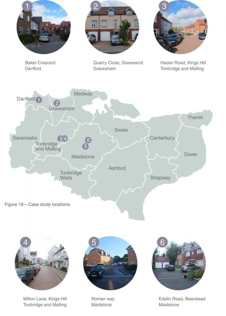
The six case studies, shown on the plan below, include two schemes on the edge of the London Conurbation in Dartford and Gravesend. Two further schemes are in the new village of Kings Hill south of Malling and the final two are on the outskirts of Maidstone.
We undertook site surveys of each of the estates in September 2013 early on a Saturday morning. It had become clear from an earlier visit that we needed to wait until the end of the school holidays and to look at the situation over night at the weekend when the problems are at their most severe. Even during the survey period it became clear that the situation eased as the morning progressed so in each case study we indicate the time of the survey.
 Case Study Sites
Case study 1: Baker Crescent, Dartford
Survey undertaken – 1.00-2.00pm Saturday 7th September 2013
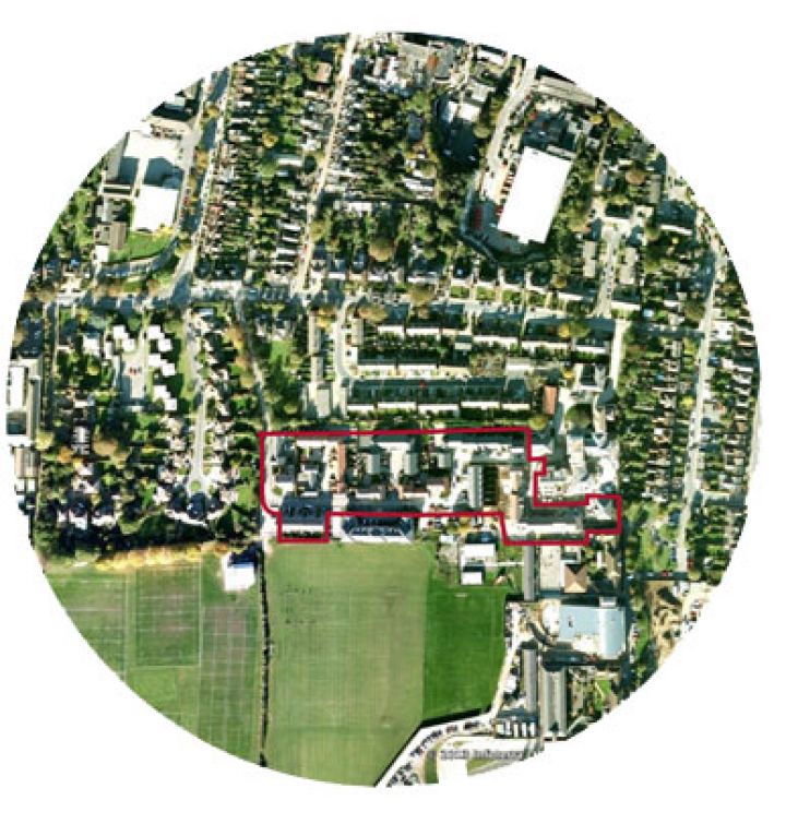
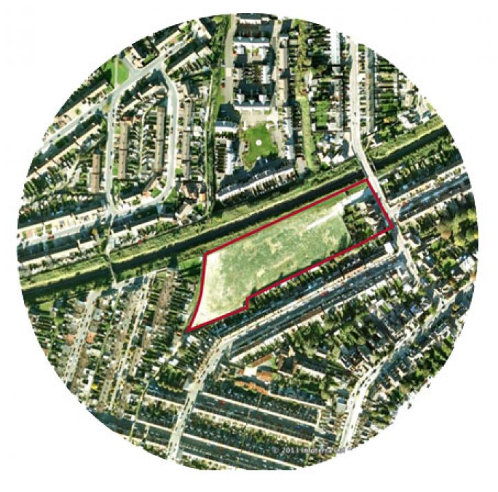
Baker Crescent is the most urban of the schemes surveyed. It was developed on a former school site within 600m of the centre of Dartford. As a result it is well served with facilities with good bus services, shops services and schools within a 5 minute walk of the site.
The scheme includes 91 homes all of which are houses although there are adjacent phases of the development that include apartments. The case study site covers 1.56 ha and is therefore built at a high density of 58 units/ha since most of the houses are terraced.
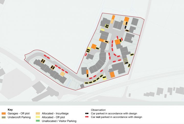
19 of the properties have integral garages and all of these also have a driveway in front of the garage. Because the garages were closed it wasn’t possible to assess whether they were used for parking. However, the fact that most of the garages had cars parked in front of them, were blocked by bins or appeared too small to use, suggested that very few were used for parking. In two properties with garages cars were parked on the property’s front lawn.
The remainder of the allocated parking is in parking courts most of which are at the rear of properties. The scheme includes a mews housetype with accommodation on the first floor and three bays on the ground floor. One of these bays is used to provide vehicle access to a parking court to the rear and the other two are open car ports. Because these were double spaces they did appear to be used. There are only five designated unallocated on-street spaces.
On the site visit we observed 76 cars parked on the estate. However this was one of the last sites to be surveyed by which time many vehicles may have left the estate. Almost a quarter of these parked cars were parked outside allocated spaces. Bollards appeared to have been retrofitted on the corners to prevent people parking there suggesting that this unregulated parking had caused problems in the past although on the day we visited the informal parking was not causing any obstruction.
The amount of informal parking suggests either there had been far more cars parked over night and the parking overflowed onto the street, or people prefer to park informally outside their home rather than in parking courts that are not well overlooked and in some cases quite distant from their home. From our observations, the parking courts do appear underused and we suspect the latter.
 Baker Crescent Aerial
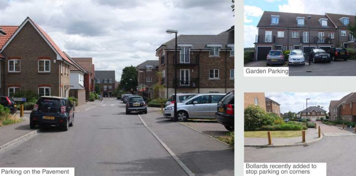 Baker Crescent Photos
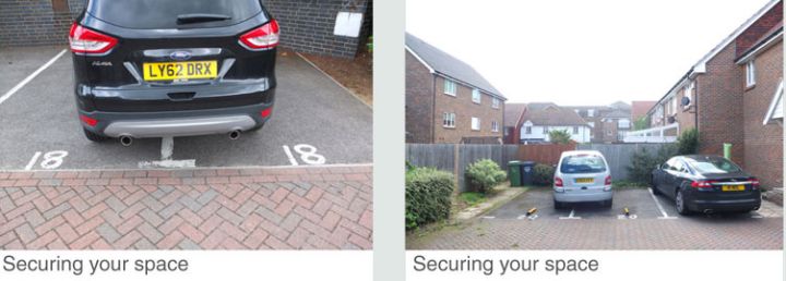 Baker Crescent Photos
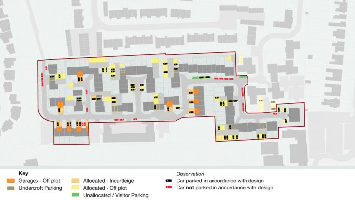
Case study 2: Quarry Close, Gravesend
Survey undertaken – 11.30-12.10pm Saturday 7th September 2013
Quarry Close is a backland development site along a railway line that has been opened up by the acquisition of a property to create a road access. It is located close to the centre of Gravesend, about 800m from the town centre and within five minutes walk of bus stops and two primary schools.
The scheme includes 60 homes, with 42 houses and 19 apartments. Part of the site along the railway remains undeveloped and it is clear from the planning history that there have been misgivings about the development of the site. The initial application was only allowed on appeal and a subsequent application to develop the land along the railway was refused. With this undeveloped land the density of the scheme is 42 units/ha, without it the density rises to 50 units/ha. The apartments are in two, three storey blocks and the houses built as short terraces.
The scheme includes 22 garages. Ten of these are in garage blocks separate from the houses and the remainder are integral to the houses. These garages are clearly too small for most of the cars on the site, something confirmed by residents during the site visit.
There are 60 allocated parking spaces within the scheme plus 14 unallocated spaces. Each of the spaces, even those in front gardens, is marked with road paint either with the owner’s house number or as ‘visitor’. The road is unadopted and is subject to parking enforcement. Cars parked illegally are clamped by a private company, something that is apparently rigorously enforced. As a result there are signs of severe parking stress on the estate. A couple of the people that we spoke to during the survey suggested that parking was a major issue, that they were no longer talking to their neighbours and that there was no community as a result. Because of the clamping there were only three cars parked on the street but many of the houses were parking on their front garden. One of the residents reported that it was impossible to have a party because there was nowhere for guests to park.
We observed 43 cars parked on the estate although it was late morning by the time of the survey and many cars will have left. Unlike case study one it would appear that the stresses are due to the overall lack of spaces rather than the unattractiveness of allocated spaces. The parking controls remove one of the main safety valves for parking, creating severe tension.
 Quarry Close Aerial
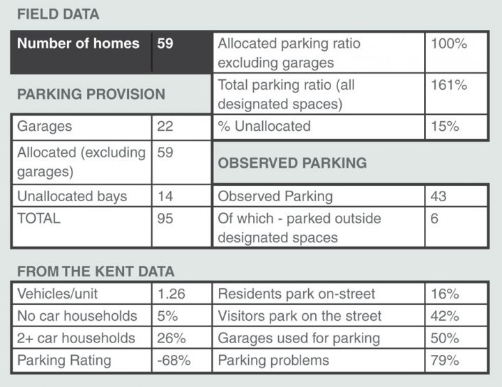 Field Data
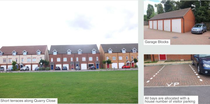 Quarry Close Photos
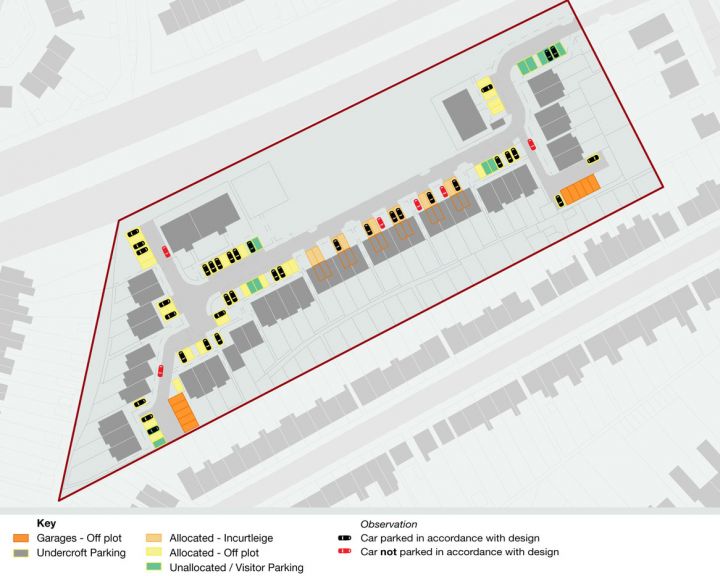
Case study 3: Hazen Road, Kings Hill
Survey undertaken – 09:45-10:30am Saturday 7th September 2013
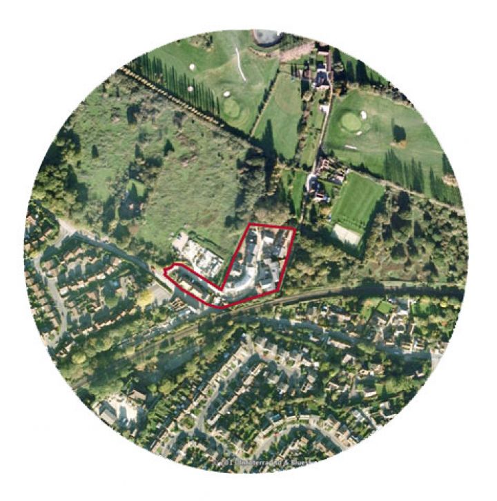
This and the next case study are part of the Kings Hill new village to the south of Malling in the Tonbridge and Malling District. The scheme is one of a number of new villages planned in Kent in the late 1980s, the most well known being New Ash Green. Kings Hill has been developed on a former RAF Airfield and was started in 1989 when there were plans for 2,750 homes of which 2,000 have been built so far.
The village includes two supermarkets, two primary schools (but not yet a secondary school) and a reasonable range of local services.The Hazen Road scheme is just north of the local centre and is within 5 minutes walk of the Asda and Waitrose supermarkets, bus stops and employment premises. The two primary schools are slightly further away but are within a 10 minute walk. Although these are closeby, the whole design of the area, the wide roads and roundabouts and extensive grass verges mitigate against walking, and it would appear that most journeys are made by car.
The Hazen Road scheme includes 122 homes most of which are terraced houses and semi detached units with a few mews units over garages. The layout is very tight with a density of just under 46 units/ha. Hazen Road is designed as a tight winding village street that varies in width but is often little more than 10m wide between properties.
There are 88 garages in the scheme none of which are integrated into the houses. A number of houses have attached garages and there are also garages under mews blocks and in covered parking court areas. The garages seemed to be slightly larger that those in the town-house schemes but nevertheless many had cars parked in front of them implying that they were not being used.
There are 141 allocated parking spaces on the scheme (excluding the garages). Most of these are in quite large rear parking courts, which are accessed via narrow side streets. The parking courts appear to be accessible from back gardens and most also have houses and mews units facing onto them. There are virtually no unallocated visitor parking spaces, just five in individual bays on-street that take up a huge amount of space.
In the visit, which took place mid morning, there were 101 cars parked in the estate. More than a quarter of these were parked in undesignated spaces including many along Hazen Road. Because of the width of the road these cars were all parked partly on the pavement, which in many cases was entirely blocked by the car. This is despite the fact that the deeds of the houses apparently do not allow parking on this street and the fact that it is a point of frustration for some residents. By contrast some of the rear parking courts were quite underused.
As with the first case study it is difficult to know how much of the informal parking is the result of undersupply and how much is the result of people’s aversion to using rear parking courts. Observations and discussions on site suggest the latter is probably the more important factor.
 Hazen Road Aerial
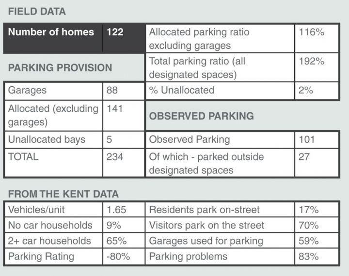 Field Data
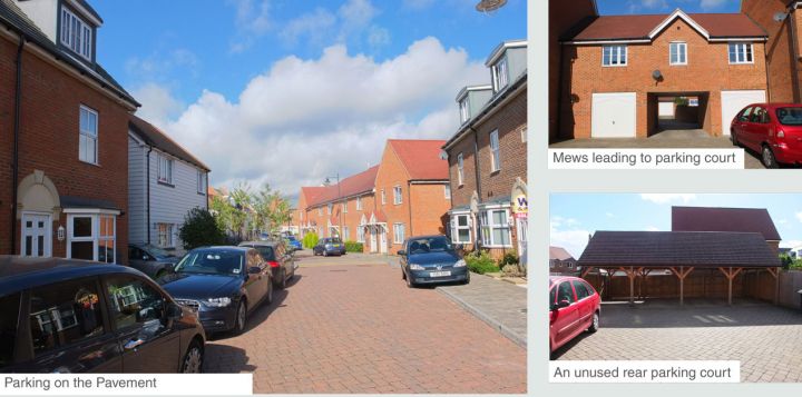 Hazen Road Photos
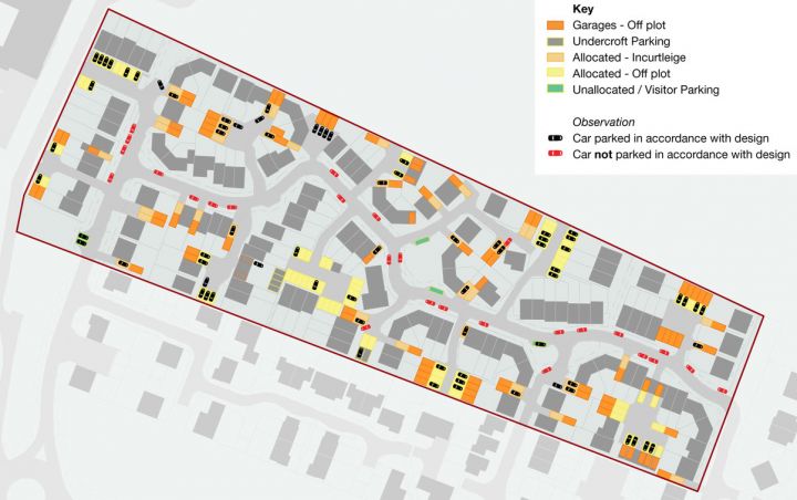
Case study 4: Milton Lane, Kings Hill
Survey undertaken – 09:45-10:30am Saturday 7th September 2013
This is second scheme within Kings Hill. It is located just to the south of the local centre and so is within an easy five minute walk of a range of local facilities as well as being directly adjacent to one of the primary schools. There are also bus stops a short walk to the south of the scheme.
The scheme is similar to Hazen Road being designed as a narrow country lane only 10-11m wide between houses with even tighter lanes branching off to either side.
The element of the scheme we have looked at includes 58 homes including one block of 5 flats. These are built at a density of 44 units per hectare, however they are part of a wider estate which is probably built at slightly higher density than this. This scheme is incredibly dense, with a fine grain, many of the houses having little or no garden.
The main difference with Hazen Road is that the parking courts are smaller and much of the allocated parking is within the curtilage of the property . There are more garages and most of the garages also have a parking space in front of them.
This probably means that all of the larger units have two spaces including the garage, and the smaller houses have one allocated space. It was again not possible to assess the number of cars parked in the garages but it seemed likely that these were not used for parking, as in the other estates. There is no unallocated visitor parking on the site at all.
At the time of the visit there were 68 vehicles parked on the estate, more than the number of homes.
Further more, half of these were parked on the street despite the deeds of the houses supposedly forbidding this.
This is likely to be due to a preference, as in other schemes, for parking in front of the property. The fact that there are no unallocated spaces and limited spaces in garages, also means that households with more than one car have no choice but to park on the street.
 Milton Lane Aerial
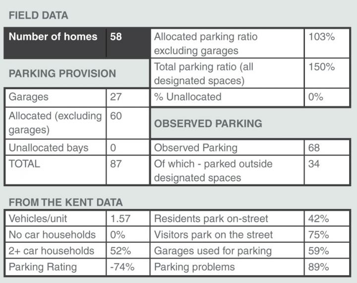 Field Data
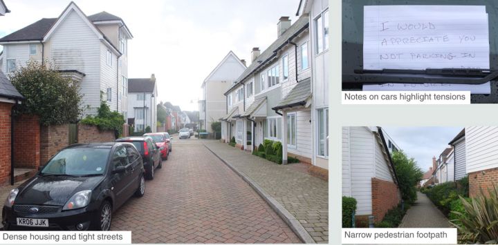 Milton Lane Photos
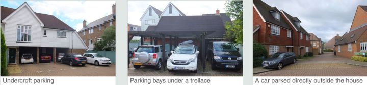 Milton Lane Photos
Case study 5: Roman Way, Maidstone
Survey undertaken – 7.00-7.45am Saturday 7th September 2013
This is part of a modest urban extension on the southern edge of Maidstone. The scheme was previously fields and sits next to a large social housing estate. This estate is well served by facilities with bus routes, a local parade of shops and a primary school. However the road layout, the connections between these facilities and Roman Way are not particularly clear.
The estate includes 96 houses most of which are either semi detached or in short terraces. The estate consists of one long cul-de-sac and is built at a reasonably high density of 46 units/ha.
Just over half the units are provided with garages and of these, around half were attached to houses and the other half were in parking courts. The latter were not well overlooked and some had been fitted with additional locks suggesting security problems. The garages were the same size as in other schemes and many appeared to be unused. At the entrance to the site there are a series of detached houses with integral garages that were almost certainly not being used for parking.
There are 109 allocated parking spaces within the scheme. There are two rear parking courts but most of the allocated parking is in front of the housing directly off the street. All of the allocated parking is marked with the relevant house number, an indication perhaps that there have been tensions in the past. There are only five designated visitor parking spaces at the entrance to the estate, clearly visitors are expected to park here and walk the rest of the way.
This scheme was visited before eight in the morning so that the actual number of cars parked is probably a better indication of demand than those sites visited later in the day. At the time of the visit there were 126 cars parked on the estate which exceeded the number of available spaces (excluding garages). As you would expect most of the allocated spaces were occupied and cars were parked everywhere on the street including some entirely on the pavement and others blocking visibility on corners.
 Roman Way Aerial
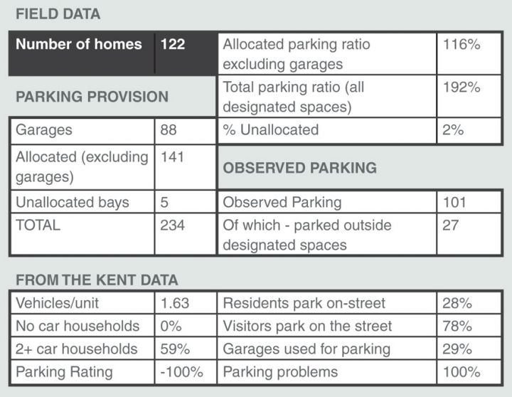 Field Data
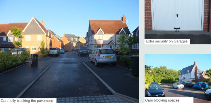 Roman Way Photos
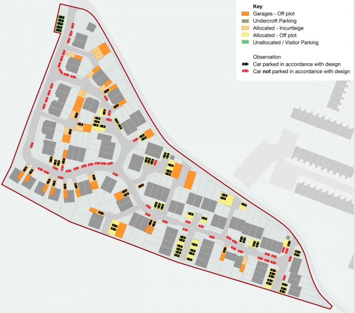
Case study 6: Edelin Road, Bearstead
Survey undertaken – 6.30-7.00am Saturday 7th September 2013
This small estate lies on the north east edge of Maidstone near the village of Bearstead. While it is within a 7 or 8 minute walk of Bearstead Train Station and is opposite a pub, it is otherwise quite isolated from facilities with no nearby shops, bus services and more than a ten minute walk to the local junior school.
The scheme consists of 32 homes on a long cul-de-sac. The houses on the main road are substantial properties which back onto this cul-de-sac and have garages accessed from the rear. The other properties are mostly large houses with two mews units built over garages.
As with all of the schemes the garages appear to be too small and unused. Indeed there have been planning applications for at least two of them to be turned into living accommodation. The other allocated spaces are in driveways, in two small parking courts and uniquely for this scheme on-street. The road presumably is not adopted because the on-street parking spaces on the bend are marked with house numbers indicating that they are allocated.
There were 44 cars parked on the estate at the time of our visit just under half of which were not in allocated spaces. These cars did make the estate feel congested and made manoeuvring difficult. The road on the bend does not have a pavement meaning that cars are parked partly on the verges causing damage and meaning that residents need to walk in the roadway.
 Edelin Road Aerial
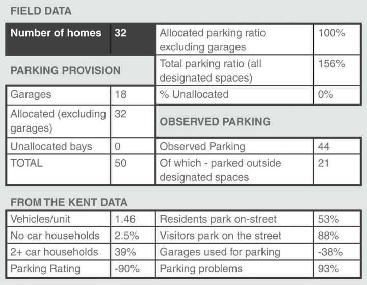 Field Data
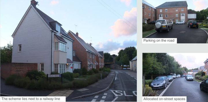 Edelin Road Photos
 Edelin Road Photos